The History of Victorias (Philippines) - CHAPTER 3: DID THE EARLY SETTLERS COME FROM ANINIPAY DURING THE PRE-HISPANIC PERIOD?
If the history written by Pedro Monteclaro in Maragtas is true, in the 1200s CE, ten datus from Borneo, led by Datu Puti (whose name in the present time has been unfortunately reduced to be cooking condiment) arrived at Aninipay, the old name of Panay Island, and asked Pulpulan, the chieftain of the ati natives, and his son Marikudo for land where they could settle.
The ati people are an ethnic group of short, dark-skineed people with curly hair who were the earliest occupants of the islands with their own culture and way of living (sadly, they have been ignored and relegated to a minority).
And over the centuries, long before Ferdinand Magellan arrived in the archipelago, the communities of those Borean datus must have thrived in the plains and along the coastlines of Aninipay. These settlers were expert seafarers even before they arrived at Aninipay. They treated the sea, not as barriers, but as highways that enabled them to reach other islands.
Like all early settlements, a river is always a required element. For survival, inhabitants needed a source of water for drinking, cooking, washing, and other daily needs. A river is also a source for irrigating their vegetation, and due to the absence of roads or long, cleared paths, a river is a navigable passage into the inner areas of an island.
The early settlers of Daan Banwa must have arrived on several wooden boats loaded with brown-skinned men, women and children, huddled together with their livestock, ornaments, pottery, amulets, instruments, plant seeds, and Bornean culture and traditions.
If they were from Aninipay, the amihan winds would have carried them here to this northern part of Buglas, the old name of Negros Island, to an area with a river surrounded by fertile land. Their men must have scouted and chosen this place several moons before, a place near the mouth of a silty river where they could migrate to for reasons that would have included the need for a bigger, fertile area for a growing clan, or perhaps to avoid conflict with other clans and tribes. Although avoiding gossipy neighbors could have been one of the reasons, it wouldn't have been enough to cross the Iloilo Strait for.
Here, they found mangroves, nipa and malihaw plants, and with their experience in agriculture, they planted and raised fruit-bearing trees and vegetables, and cultivated rice that fed their clan a few seasons during the year alternately with root crops.
This community must have thrived for a long period and must have even lived in harmony with the local ati tribes in the neighboring forests full of trees, vegetation and wild animals thriving along the three rivers that converge as one and now known as Malihaw. During the period of these early communities, these rivers overflowed when their banks could not contain the deluge from the mountains and the incoming high tides from the sea.
For those familiar with the geography of Victorias, the Malihaw River is the one flowing through Brgy. 18A, near the Victorias Golf and Country Club of the Victorias Milling Company, while the Magnanud River flows through Brgy. 8. Although at one point, both rivers are 4.1 kilometers apart, they converge as one at a spot 660 meters north of 'Bangga Daan', the name of the intersection along the national highway that leads into Daan Banwa. Taytay Bahô is Malihaw River, while Magnanud River is the one that floods the Victorias Memorial Park as well as Barangays 1 and 2.
If ever there was an ancient settlement in Daan Banwa, its disappearance might have been caused by bloody attacks from Moro pirates who roamed around the Visayan seas to plunder villages, and kidnap women and children to make as wives or sell as slaves; natural disasters like destructive floods from the overflowing rivers; or deadly diseases that would have eradicated a tribe. Whatever it was, we will never know.
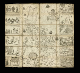
(The 1734 Murillo-Velarde map, the oldest map of the Philippines, showing the islands of Panay and Isla de Negros.
Map courtesy of Murillo Velarde Map website)


Comments
Post a Comment